
On July 4th, 2013, the ONERA Fauga Mauzac center, near Toulouse, inaugurated LIMA, ONERA's research platform to develop the use of new airborne imaging technologies.
The new airborne imagery technologies in involved are: high spatial resolution, high spectral resolution (hyperspectral) and 3D laser imaging.
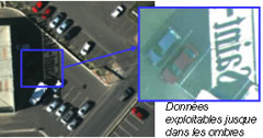

High resolution image (5 cm) and hyperspectral image (hundreds of spectral images of the same scene)
High spatial resolution allows images with a resolution of up to a few centimeters to be obtained, in the visible spectrum. Hyperspectral imaging allows hundreds of images of the same scene to be obtained at different wavelengths, corresponding to the same amount of "colors" covering the visible and near infrared parts of the spectrum and offering a powerful way of discriminating between the various elements of a scene. In regard to "active" 3D laser imaging, it allows a 3D scene to be reconstructed by scanning it with a laser beam and analyzing the backscattered signal (and it even works at night or in foggy weather).
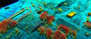
3D laser image
In order to facilitate access to these technologies and master their complexity, Onera will provide operating tools to its partners and customers, such as databases, processing and computer operating channels, as well as the necessary support (training, research partnership, etc.). The organization of the "idea to completed result" airborne campaigns, the in-flight performance evaluation and the experimental characterization of the processing and results are part of the service provided by LIMA.
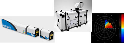
LIMA is backed by Onera’s airborne means and those of its partners: the Onera Ressac and AJS drones, the Onera Busard glider, Sethi pods (AVdef), IGN, Safire, etc.

Three Onera means associated with LIMA: the Ressac drone, the Busard and Sethi
The fields of application are varied:
- agriculture, forestry and water management
- sustainable development (energy efficiency in buildings, human impact)
- urban development (thematic maps, traffic optimization or street lighting optimization, biodiversity)
- the environment (air and water quality, characterization of pollutant emissions)
- risks (pollution, industrial accidents, floods, forest fires)
- defense and security (site surveillance, border surveillance, information, etc.)
- space sciences, meteorology and archeology
- resource exploration (energy, water, etc.)
LIMA is a multi-sensor image research center, located at the Onera Toulouse center, whose operating room is open to its partners. It also offers in-flight calibration means and on-site validation means:
- means for field measurements
- a 70-hectare instrumented reference site: the Fauga-Mauzac center
- mobile infrastructure in France and abroad
LIMA’s mobile means for atmospheric characterization
LIMA has been funded to the tune of 6.85 million Euros, including 4.12 million Euros from the European Regional Development Fund (ERDF), the Metropolitan Toulouse, Midi-Pyrénées Region State project contract