
A year after the GOCE satellite (ESA) had finished its mission in the atmosphere, scientists have revealed the progress made in the understanding of ocean currents.
Using the gradiometer, which is the instrument at the core of the ESA GOCE mission (2009 - 2012) that includes six accelerometer chains developed and implemented by ONERA, scientists have obtained gravity variation maps of unparalleled precision. The results were presented at the end of 2014 to UNESCO on the occasion of the 5th International GOCE User Workshop. Data has been obtained in many fields, such as ocean currents, the unification of geodetic coordinate reference frames or some deep movements of the Earth, etc.
A new model for ocean currents could be determined from the GOCE data, providing the most precise global map ever obtained. It has been validated using measurements from in-situ buoys.
The GOCE data enable very important progress to be made in the Earth numerical models (ocean, atmosphere, solid Earth, etc.) used for the prediction of climate change.
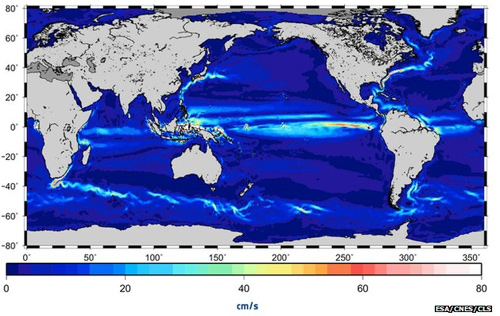
Ocean current speed in cm/s obtained from the GOCE data