Physics
Physics Domain - research topics of the Optics and Associated Techniques (DOTA)
Scientific Officer
PHY topics at the DOTA department
- Optoelectronics: photodetection and nanophotonics DOTA
- Environment and signatures for optronic sensors DOTA
- Fiber lasers, lidars and 3D imagers DOTA
- Active and passive remote sensing DOTA
- Wave surface control, adaptive optics DOTA
- Optical sensors and hyperspectral imagers DOTA
PHY stands for the Physics Scientific Domain of ONERA
Optoelectronics: photodetection and nanophotonics
DOTA Patrick Bouchon, Sophie Derelle. (POC name.surname@onera.fr)
Areas of excellence
- Infrared photodetection: modeling, pixel FTM, pixel/matrix characterization, noise, cryogenics, semiconductor physics, quantum heterostructures
- Low light level sensors
- Emerging infrared technologies: quantum dots, type 2 superlattices, gallium-free superlattices, nanostructured detectors, nanostructured filtersTerahertz and millimeter waves: terahertz spectroscopy, terahertz detection, terahertz imaging, THz-IR conversion
- Nanophotonics: metamaterials, metasurfaces, plasmonics, nano-antennas, 2D
- materials, optical phase masks for phase and polarization control, ENZ metamaterials, doped semiconductors, quantum dots
- Electromagnetic modeling: modal methods, finite elements, inverse design, optimization
- Light-matter interaction at the nano scale: nonlinear effects (SHG, DFG, Kerr effect, 4-wave mixing), SEIRA, SPR, infrared ellipsometry, near-field studies.
- Nanothermics: thermal emission, nanosources, thermal detection, thermal conversion, heat transfer in nanostructures
Examples
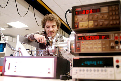 AIQUIDO laboratory - Implementation and characterization of infrared optical detectors
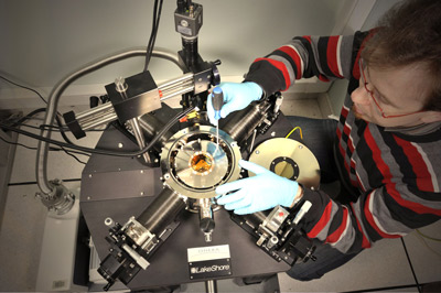 ONDA nanomaterials platform - Design and characterization of nanostructured components for infrared applications.
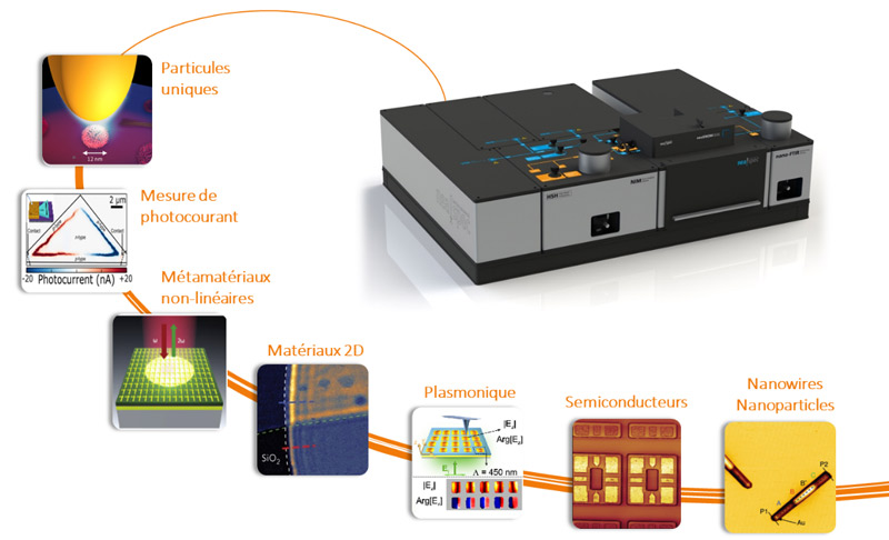
The NASCAA instrument, the only one of its kind in the EU, provides access to an extremely wide range of characterizations on samples made up of nanostructures, nanomaterials (and 2D materials) and optical components, with a spatial resolution of around ten nanometers (well below the diffraction limit):
- Characterization of sample topography
- Measurement of the reflection/absorption spectrum of samples
- Electro-optical characterization: spectrally and spatially resolved photocurrent
- Complete electromagnetic field measurement: amplitude and phase
- For wavelengths from visible to terahert
- For temperatures from 8 K to 300 K
This equipment, based on recent developments by NeaSpec, was obtained thanks to OPII
funding.
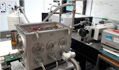 The MIRCOS bench is a multi-purpose cryogenic bench, unique in France. Its aim is to provide the capability to develop innovative electro-optical measurement techniques for research projects carried out in collaboration with other research centers (CEA-LETI, IRFU,
IES, etc.) and industry. This facility enables us to characterize the detector alone (spectral response, FTM, etc.), optical components or a complete instrument (detector+optics) in a completely controlled environment, which is essential in the infrared range (MWIR=3-5μm band and LWIR=8-12μm band), where the thermal background can be very penalizing.
The value of the MIRCOS test bench extends far beyond the measurement of the spatial response or FTM for future small-pixel detectors, since it would make it possible, subject to the integration of the new equipment mentioned below :
- Improve our methods for measuring quantum efficiency (and spectral response) particularly in the LWIR range, for QCD or T2SL detectors at the technological maturation stage (ANR, theses by C. Gureghian and A. Ramiandrasoa in collaboration with IES).
- Calibration and expertise work on multichannel instruments in laboratory cryostats (such as the SIM-ONE or Simagaz cameras in the LWIR or FILAMENT in the MWIR) and the future Microspoc LWIR spectrometer (discussions underway with Lynred as part of the PRI OSMOSIS and PR CAMUS).
MIRCOS came into being in 2017 thanks to ASTRE funding from the Essonne General Council (total budget 291k€, ONERA share 33%) obtained at the end of 2015.
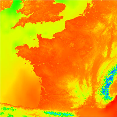
Environment and signatures for optronic sensors
DOTA Sidonie Lefebvre, Romain Ceolato. (POC name.surname@onera.fr)
Scientific and technical skills:
- Radiative and heat transfer modeling
- Background clutter modeling (land, clouds, sea, atmosphere)
- Nightglow radiation study
- Acquisition and use of experimental data for model validation - capitalization in reference databases
- Experimental study and fine modeling of optical signatures on targets - development of behavioral models
- Statistical evaluation of signatures, study of climatologies and their impact on signature dispersions
- Methodologies for validating scene generators and evaluating the performance of digital color imaging systems with a human observer at the end of the chain.
Main scientific and technical objectives:
- Provision of experimental and simulated radiative quantities from the observed scene to assess the performance of optronic sensors
- Optronics environment referent for DGA programs
Examples
Characterizing the optical properties of materials
Nightglow radiation study
The MATISSE radiative transfer code
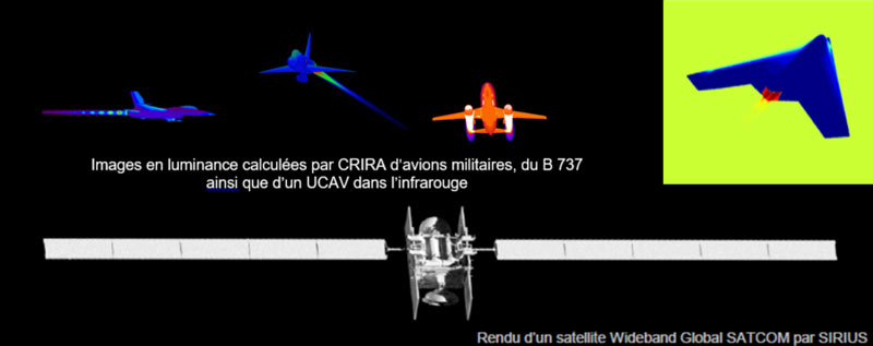
Modeling the optical and infrared signatures of aircraft and satellites
The DOTA department is developing the CRIRA and SIRIUS tools for modeling the optical and infrared signatures of aircraft and satellites. By signature we mean all the information used to characterize the object's radiation: intensity, luminance images, spectra and polarization. The aim is to provide representative simulations of these objects in order to respond to the needs of dimensioning or evaluating the optronic sensors that observe them.
The latest developments in these tools concern stealth aircraft, emerging hypersonic aircraft and satellite surveillance.
Fiber lasers, lidars and 3D imagers
DOTA Nicolas Cézard, Laurent Lombard. (POC name.surname@onera.fr)
Scientific and technical skills:
- Laser-matter interaction: materials and atmosphere, scattering media, all weather conditions
- Energetic, temporal, spectral and spatial characterization of laser beams (e.g. M², RIN, phase noise, etc.)
- Modeling physical phenomena in passive and doped optical fibers
- Photodetection techniques and associated signal processing: heterodyne detection, photon counting, matrix sensors
- Laser modulation/Lidar architecture/signal processing co-design (e.g. FMCW Lidar, frequency comb Lidar, 3D focal plane LiDAR)
- Lidar signal processing: full wave, compressive sensing, deconvolution
- Real-time and embedded electronics and programming for piloting, control and signal processing (e.g. GPUs, FPGAs)
- Laser instrument integration and demonstration outside the laboratory: stand-alone instruments, on mobile carriers on land, in the air (aircraft and drones) and in space, in underwater environments, etc.
Main scientific and technical objectives:
- Laser remote sensing instruments: 3D telemeter and imager, 3D LiDAR, Lidar televelocimeter, atmospheric Lidar (wind speed, gas concentration, aerosol characterization, temperature), Laser vibrometer
- Laser weapons and laser vulnerability
- Laser system sources and architecture: fiber lasers, hybrid architecture, coherent and incoherent laser combinations
Examples
BOFIX laser and Lidar LIVE For the study of air mass dynamics, a wind measurement lidar was designed incorporating a specially developed laser source. The integration of this lidar on a test aircraft demonstrated the measurement of the wind vector from an altitude of 5
km down to the ground.
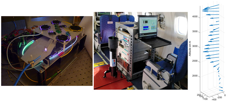
Airborne Lidar LIVE. Left: 500 μJ high-energy pulse laser, center: Lidar Live installed in the ATR42, right: example of wind vector reconstruction as a function of altitude.
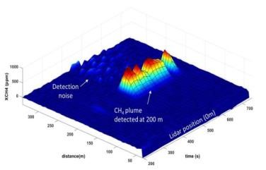
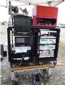
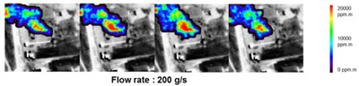
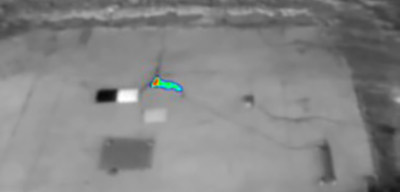
VEGA Lidar for remote methane measurement. Left: measured spatial profile of methane concentration; right: the demonstrator..
The development of the VEGA lidar, dedicated to the remote measurement of methane flow, was based on the results of two theses (P. Benoit for the laser source and S. Le Méhauté for the lidar) and on the multidisciplinary skills of the Laser Source and Lidar Systems team (laser/lidar co-design, instrument integration, signal processing). During several test campaigns, this DIAL/Doppler fibered lidar demonstrated its performance, as well as the robustness and reliability of a fully fibered architecture.
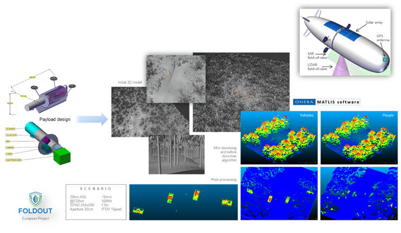
The MATLIS software developed by ONERA simulates the performance of a laser imager, taking into account the physical phenomena involved: characteristics of the laser source, propagation of the laser beam in the atmosphere whatever the meteorological conditions, laser-matter interaction, scene dynamics (movement of objects and dynamic aerosols) and integration of "sensor" models. MATLIS software is used upstream of any new development of 3D LiDAR systems.
Active and passive remote sensing
DOTA Pierre-Yves Foucher, Sophie Fabre. (POC name.surname@onera.fr)
Scientific purposes and applications :
- Detect and quantify bio-physical-chemical variables directly or indirectly associated with human activity using multimodal remote sensing at different spatial, spectral and temporal scales.
- Characterization of human activity for defense, security and environmental purposes
Skills base:
- Remote sensing in the optical range (0.4-12.0 μm)
- active / passive
- high spatial resolution (cm to decameters)
- any type of platform (ground, drone, aircraft, satellite)
- optical/microwave complementarity
- Key points
- multi-scale approach
- validation
- poor weather conditions
- reducing preconceptions
Examples
HYPERSPECTRAL SOL Validations for CH4: TELOPS instrument (2 to 8cm-1 spectral
resolution)
Real-time gas quantification for infrared spectral imaging. Concept : Spectral/spatial
processing to estimate the spectral transmission of a target gas and trace it to concentrations/masses/flows. Collaborations / Transfers: TELOPS, TOTAL, Noxant, Bertin. Validation instruments: Hyper Cam (Telops) , HyTES (JPL), SIMAGAZ (FUI-IMAGAZ), Hyspex (NEO)
 Airborne hyperspectral - validations for CH4: TELOPS instrument (4 cm-1 spectral
resolution)
 Multispectral ground/drone - validations for CH4: SIMAGAZ instrument (4 spectral bands)
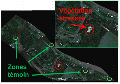 Quantification of hydrocarbons through indirect effects on vegetation. Detection of
stressed vegetation linked to the presence of hydrocarbons in the soil (airborne hyperspectral imagery - HS, satellite multispectral).
![Carte de délinéation de couronnes d’arbre [Erudel 2018]](/sites/default/files/recherche/phy/V2-teledetection-couronnedarbres.jpg) Tree crown delineation map [Erudel 2018]
Tree crown delineation map [Erudel 2018]
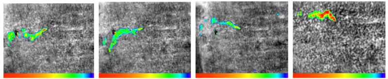
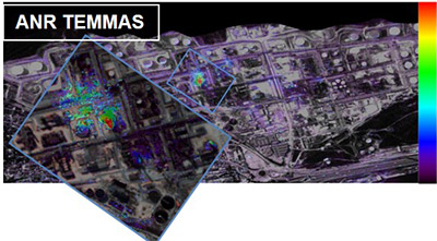 Detection and characterization of a source of fine particles on an industrial site (ANR TEMMAS)
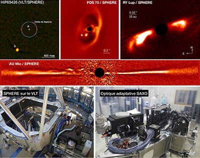
Wave surface control, adaptive optics
DOTA Serge Meimon, Jean-François Sauvage. (POC name.surname@onera.fr)
Scientific and technical skills:
- Phase and amplitude measurement and imaging
- Active and adaptive optics
- Optical interferometry and multi-pupil imaging
- Automation and real-time control laws
- Characterization (modeling and measurement) of optical effects of atmospheric turbulence
- Co-phasing and beam shaping (coherent and incoherent)
- Propagation through turbulence and imaging through complex media
- Signal and image processing & artificial intelligence
- Co-design for high angular resolution instruments
Main scientific and technical objectives
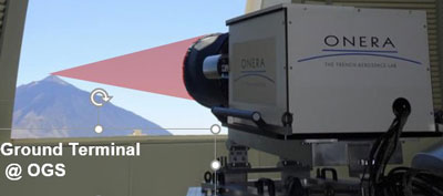
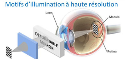
- High-resolution, high-contrast imaging for space surveillance (Astronomy and SSA)
- Biomedical imaging
- Free-space optical telecommunications
- Optical metrology
- Contributions to the laser weapon, endo-atmospheric imaging, high-resolution imaging of the Earth from space, imaging through turbid and highly scattering media
Examples
Optical sensors and hyperspectral imagers
DOTA Guillaume Druart, Yann Ferrec. (POC name.surname@onera.fr)
Socle de compétences scientifiques et techniques :
- Study of optical components or atypical optical concepts
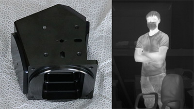
multichannel architectures, bio-inspired architectures, cryogenic optics, freeform optics, graded index optics, self-imaging, lensless imaging, phase masks, kaleidoscope, plenoptic imaging, interferometric blades, birefringent blades for interferometry, PIC - A frugal approach to miniaturizing and simplifying cameras
SWAP-C issues, cryogenic cameras, infrared cameras for home automation or automotive applications, optical loads for nanosatellites - Static interferometers for Fourier transform spectrometry and spectro-imaging
hyperspectral cameras, high-speed spectrometers - Multispectral infrared imagers with cooled or uncooled detectors
- Performance modeling of optical instruments
radiometric models, range calculation, image simulation - Development of characterization benches for instrument acceptance testing
NETD, BSFR, FTM by spot scan or inclined test pattern, distortion, calibration in a fume hood - Physical processing of images acquired from a scene,
radiometric and spectral image processing in luminance or brightness temperature, shutterless algorithms, spectrum reconstruction from interferograms, subpixel image registration, digital elevation model, gap interferogram processing, image resampling methods - Phase imaging
- Development of new optical system design strategies
end-to-end approach, differential ray tracing, Simultaneous Multiple Surfaces method, artificial intelligence, construction of surfaces from the parabasal ray - Imaging instrument integration and demonstration outside the laboratory
stand-alone instruments, on land, air and space mobile carriers - Line-of-sight servo-control for airborne imaging and target tracking
Examples
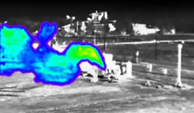
SIMAGAZ, the first compact cryogenic multispectral camera for gas detection, is based on cryogenic optics and specific high-performance image processing. While the application need was expressed by TotalEnergies in the course of a research-industry partnership, a preindustrial demonstrator was made possible thanks to a single interministerial fund - FUI Imagaz -, demonstrating exceptional performance in terms of quantitative visualization and temporal evolution of a methane plume.
First infrared image obtained with a freeform lens. The lens, which uses a freeform mirror architecture, was designed as part of a thesis. These optics have no axis or center of symmetry (a principle applied to progressive lenses), and thus allow a greater number of degrees of freedom in optical design. The benefits sought from this freedom are improved aperture,
performance and compactness of imaging systems.
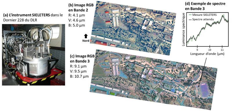
The SIELETERS hyperspectral instrument is a high-performance airborne hyperspectral imager that can obtain 205 spectral images of the same scene in the infrared (from 3.0 μm to 5.4 μm and from 8.1 μm to 11.8 μm). Its spectral resolution ranges from 13 nm to 90 nm. It is based on Fourier transform static spectro-imager technology.
First airborne campaign for NanoCarb, a miniature imaging spectrometer for measuring greenhouse gases NanoCarb is an imaging spectrometer dedicated to measuring greenhouse gases, developed by UGA and Onera. Its compact size means it can be integrated into a mini-satellite, paving the way for a constellation of satellites dedicated to greenhouse gas mapping, with better than daily revisit and a ground pitch of the order of a kilometer (H2020 Scarbo project: https://scarbo-h2020.eu/).