DOTA - Optics and Associated Techniques
- ONERA
- Scientific Departments
- DOTA - Optics and Associated Techniques
- Research units
DOTA - Research units
CIO | ERIO | HRA | IODI | MPSO | MVA | POS | SLS
Optronic components and instruments (CIO)
The CIO unit's mission is to study the physical properties of optronics components in order to understand their ultimate performance. This activity goes up to the development of innovative demonstrator instruments, thus pushing the technological limits in the field of Optronics.
The work is thus structured into three activities:
- Design and characterization of sub-wavelength nanostructured components. Combining physical understanding, multi-physical modeling and characterization benches of the optical properties of nanostructures, the unit offers component concepts with original properties.
- Electro-optical characterization of infrared detectors. The unit has an independent expert role based on the development of optical set-ups for the metrological characterization of the electro-optical performance of infrared detectors: ranging from 1 to 20µm, for all types of quantum or uncooled technologies.
- Design, realisation and deployment of optronic instruments. Building on the results of the two previous activities, the unit is developing innovative instruments to demonstrate and to quantify the contribution of breakthrough technologies to defence and civil needs in the optronics field. Knowledge of operational needs also allows us to play a role as a technology maturer.
The CIO unit contributes to the following themes: Optoelectronics, Optical sensors and hyperspectral imagers, Environment and signatures for optronic sensors and Adaptative optics/Wavefront measurement and control.

Left: Image taken with a high framerate infrared camera (1300 frames per second) whose proxy electronics was realised by CIO unit ; right: microspectrometer (« microspoc » concept) and part of an interferogram.
Calibration and production of optical instruments and measurements (ERIO)
The ERIO unit designs, develops and implements innovative instruments dedicated to field measurements, including airborne measurements.
The work is structured into three main areas:
- Research into technologies that can be used to produce passive optronic sensors for imaging and spectrometry purposes for civil or defence-related applications,
- The development of scientific instruments to produce radiometrically calibrated data,
- The use of a unique set of measurement instruments and associated methodologies to improve knowledge of the optronics environment (all quantities that contribute to signals recorded by optronics sensors: atmospheric background, signatures of interest for military applications, etc.)
The ERIO unit contributes to the following themes: Optical sensors and hyperspectral imagers, Active and passive remote sensing, Environment and signatures for optronic sensors.
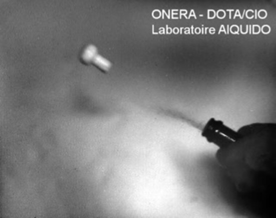
A) Infrared cryogenic hyperspectral camera, B) compact cryogenic camera for detection and quantification of methane, C) opto-mechanical design of a compact multispectral cryogenic infrared camera
High angular resolution (HRA)
The goal of the developments led in the High Angular Resolution Unit is reaching the diffraction limit of optical systems despite the perturbations undergone by the optical wave as it propagates through the environment. Key topics are the physical modeling of disturbances, their optical characterization, and their correction by opto-mechanical (active and adaptive optics) or numerical (image processing) methods. The application domains are the characterization of atmospheric turbulence, the development of adaptive optics systems of very large telescopes (VLT, E-ELT), Space observation from the ground, embedded telescope concepts with segmented or lacunary aperture, imaging and focusing of optical waves in complex environments such as atmospheric turbulence or biological tissues.
To ensure their relevancy, concepts and models are validated experimentally. Among the most recent achievements, the team counts SAXO, the extreme adaptive optics system of the SPHERE instrument (IPAG / LESIA / LAM / ESO / INAF / Geneva Univ collaboration), the demonstration of the first optical link corrected by adaptive optics with a micro-satellite (CNES / OCA / NICT collaboration) and the design of a retinal photocoagulation laser assisted by adaptive optics.
The HRA unit contributes to the following themes: Wave surface control, adaptive optics, Wave surface control, adaptive optics, Wave surface control, adaptive optics.
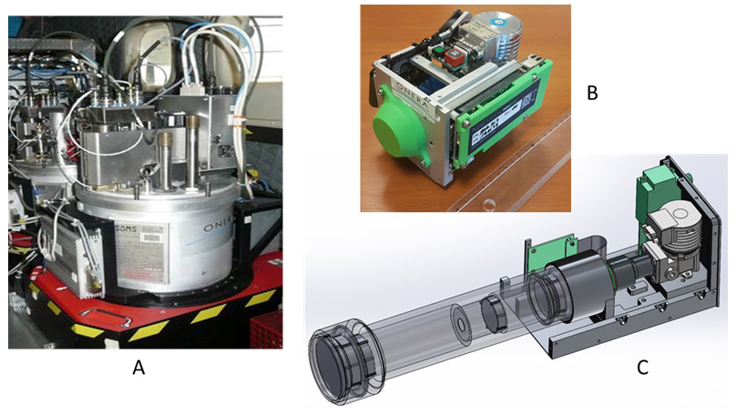
First line: left, the SPHERE instrument on the Nasmyth platform of the UT3 of the VLT; right, Beta-Pic B exoplanet direct image at the focus of the instrument. Second line: left, in vivo high resolution retinal image of nerve fibers and blood vessels with the adaptive optics bench ECURoeil at the clinical investigation center XV-XX (scale bar: 50 µm): right, turbulence profile monitor SCINDAR
Wave-materials interaction and laser systems for direct detection and imaging (IODI)
The IODI unit animates a field of research focused on laser systems for imaging and remote sensing that is divided into three main areas of application:
- Diagnosis and optical characterization of scattering media (aerosols/soot) by lidar, supplemented with setups of the atmospheric characterisation.
- Physical understanding (physical modeling, laboratory or field measurement) of the spectral, polarized and temporal optronic signatures of dense scattering media (coating, painting, emulsion, etc.) and their exploitation for detection on complex scenes.
- Laser perception to detect, recognize, identify and navigate further, in high resolution and in 3D vision, all in degraded conditions (e.g. low visibility ...).
The IODI unit focuses on two main technological areas: 3D laser imaging and multispectral/hyperspectral lidars, for which the team leads the development and implementation of systems, from the physical modelling chain to signal processing and data exploitation. It tests their complementarity with optical or radar sensors. In these two areas, IODI designs and evaluates innovative solutions to increase data performance and quality, develops compact and embedded sensors (e. g. on UAVs) and designs multi-mission and reconfigurable sensors.
The IODI unit contributes to the following themes: Fibre lasers, lidars and 3D imagers, Environment and signatures for optronic sensors, Active and passive remote sensing.
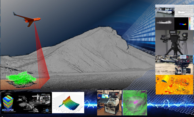
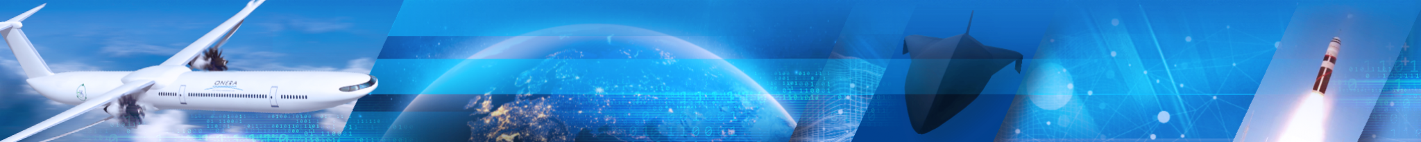
Physical Imaging by Laser. Right, from top to bottom: from photon-counting 3D Lidar prototype for long-range target identification to 3D Lidar on embedded drone for high resolution mapping for Search and Rescue applications. Bottom, left to right: from hyperspectral measurements of reflectivity in the MELOPEE laboratory to the detection of biological traces on a crime scene based on a hyperspectral laser imaging system
Physical modelling of the optronic scene (MPSO)
The mission of MPSO unit is to predict the signals that can be observed by current or future optronic sensors. This mission can be broken down into three objectives:
- Predict the impact of the optronic environment on sensors performance
- Predict threat signatures and their uncertainties
- Capitalize models and signatures
MPSO develops the atmospheric radiative transfer code named MATISSE, which is the reference code for the DGA.
The scope of the MPSO unit covers the following activities:
- Modelling radiative transfer in natural environments and targets of military interest to determine target and background signatures,
- Development and distribution of the corresponding codes to users,
- Development and distribution of (simplified) comportemental models reproducing the predominant phenomena impacting signature,
- Statistical evaluation of signatures, study of climatologies and their impact on signature dispersion,
Specification of measurement campaigns and optronic instruments, then exploitation of the measurements, in order to study the phenomenology of signatures, and to validate their modelling, specification of the corresponding databases.
The MPSO unit contributes to the following themes: Environment and signatures for optronic sensors, Active and passive remote sensing, Optical sensors and hyperspectral imagers.
Physical modeling of the optronic scene
Modelling of optronic mechanisms and associated validations (MVA)
The activity of the Modelling of optronic mechanisms and associated validations (MVA) research unit covers the following aspects:
- Assessment of the performance of optronic systems: detailed modeling of all the elements of the scene viewed by the sensor or empirical models
- Modeling of transport phenomena in heterogeneous media. This activity deals with the development and validation of thermal models for the calculation of the surface temperature field of a scene (background, simple targets) to feed infrared radiative transfer models as well as with the application of industrial codes for the modeling of more complex targets. This axis also includes the modeling of diffusion, advection-diffusion and wave propagation phenomena in property-graded media (rugate filters, photonic crystals, turbulence in the atmosphere boundary layer...).
- Modeling the infrared and visible signature of aircrafts and targets outside of the atmosphere
- Development of means for gathering airborne data over a broad spectral range (from visible to microwave), in close cooperation with DEMR (Electromagnestism and Radar Department). The unit is tasked for implementing onboard optronic sensors in ONERA’s airborne measurement resources,developing methods for pre-processing/processing data from the department’s airborne IR sensors, demonstrating and validating the potential of new observation techniques.
The MVA unit contributes to the following themes: Environment and signatures for optronic sensors, Active and passive remote sensing.

Airborne remote sensing. Soil moisture mapping using the triangle method:
(a) BUSARD motor glider
(b) Vegetation index vs. normalized gloss temperature diagram (triangle)
(c) Brightness temperature mapping
(d) Vegetation Index Mapping
(e) Soil moisture mapping (area surrounded in red: suspected water leakage)
Optical properties of scenes (POS)
The mission of the Optical Properties of Scenes (POS) research unit is to carry out studies and research in the field of optical remote sensing from visible to thermal infrared for defence, security and environmental needs from satellites, aircraft (airplanes and UAV) or from the ground.
To this end, it develops knowledge, skills and know-how to:
- Identify and characterize the variables accessible by remote sensing, characteristics of geometric, bio-physical-chemical properties of the scene components;
- Understand the physics of the observed radiation and model the inversion of the received signal to trace back to the optical properties of the observed objects;
- Develop higher level signal processing to estimate the physical properties of the environment (surface humidity, water stress of vegetation, mineralogy, pollution and its indirect effects...)
- Develop and implement methods and means for their validation
The POS unit contributes to the Active and passive remote sensing theme.
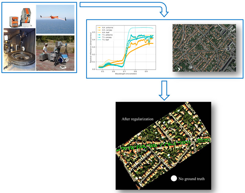
Automatic mapping of urban tree species based on multi-source remotely sensed data
Laser source and lidar systems(SLS)
The scientific and technical scope of SLS unit focuses on innovative laser systems design and development for Aerospace, Defence and Environmental applications. Here are some technologies developed at SLS and their applications:
- Measurement of gas concentration, air velocity, temperature, atmospheric density with direct or coherent detection lidars for wind or air safety applications (turbulence detection), monitoring of greenhouse gas emissions or crisis management during leaks, monitoring of air pollution ...
- Measurement of vibrometry, velocimetry and distance on "hard" targets for building and UAV surveillance applications,
- Laser sources power scaling to increase systems performances (range, accuracy, ...)
- Development of fibered sources at wavelengths hitherto not available in embeddable systems to address new applications.
The range of skill in the team enables to work on all stages of laser systems from laser sources to data processing. Skills include:
- Laser / atmosphere interaction: modeling of Mie, Rayleigh or Raman scattering ...
- Laser source: study of nonlinear effects in fibers, laser modeling, fiber spectroscopy, semiconductor lasers, coherent combination of lasers ...
- System: lidar architecture, heterodyne detection, control electronics / control / real-time acquisition ...
- Signal processing: real-time processing algorithms, optimal estimators ….
The SLS unit contributes to the Fibre lasers, lidars and 3D imagers theme.
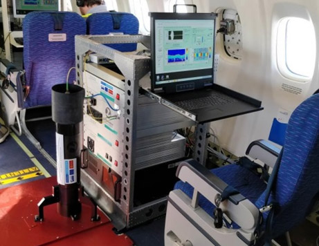
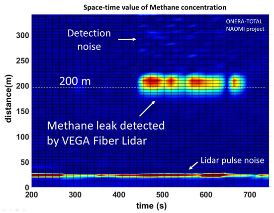
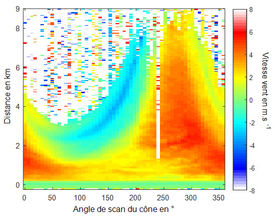
Top left, 1.5 μm high energy fiber laser specifically developed for the Lidar Live (top right) for wind fields measurement from an airplane. Bottom left, an example of methane leakage measurement with VEGA lidar (VEnt and GAz). Bottom right, wind map obtained with the lidar Live for an oblique scan from the ground