Physics
Research topics of the Electromagnetism and Radar Department (DEMR)
Scientific Officer
Research Topics of the DEMR
- Antennas, microwave materials and stealth technologies DEMR
- Electromagnetic compatibility DEMR
- Radar imaging and remote sensing DEMR
- Propagation et radiocommunications DEMR
- Simulation of the electromagnetic scene DEMR
- Systems and technologies for radar and electronic warfare DEMR
- Signal processing for radar and electronic warfare DEMR
PHY stands for the Physics Scientific Domain of ONERA
Antennas, microwave materials and stealth technologies
DEMR Juan Carlos Castelli, Cédric Martel [POC name.surname@onera.fr]
- Antenna
- Radome
- Periodic structures, metamaterials, metasurfaces (passive and active)
- Absorbing screens (passive and active)
- Radar signature measurement
- Electromagnetic characteristics of materials
Examples
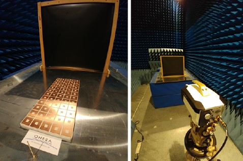 ONERA has developed a small-scale surface-wave launcher based on metamaterial technology for surface-wave radar applications (RAPID AC3M project). Experimental measurements involving ONERA (EMIR infrared thermography measurements) and GEEPS (RF measurements) have confirmed the 10 dB field amplification levels provided by the 2D launcher concept. The present device, which operates in L-band, is intended to be transposed to HF-band for coastal surveillance applications.
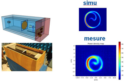 The EMIR (ElectroMagnetic InfraRed) method, created and developed at ONERA, enables almost instantaneous visualization of the radiation from a microwave source. Recent work carried out by ANYWAVES, with the participation of ONERA, has demonstrated that it is possible to integrate the EMIR method into a miniature, transportable anechoic chamber. Following on from this work, ANYWAVES set up a subsidiary (ANYFIELDS) to market an EMIR measuring device.
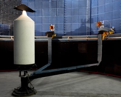
Bistatic configuration
3D monostatic
configuration
For 35 years, the BABI bistatic anechoic chamber has been one of the only RCS multistatic measurement test facility of this kind in France. Constantly upgraded, the measurement capabilities of this facility have been extended in recent years: measurements up to 90 GHz thanks to the acquisition of a latest-generation network analyzer, and the installation of a ceiling rail enabling 3D RCS measurements in both monostatic and multistatic configurations thanks to the installation of a rail on the ceiling of the chamber.
Electromagnetic compatibility
DEMR Isabelle Junqua, Daniel Prost [POC name.surname@onera.fr]
- EM coupling, EM shielding, EM protection against electromagnetic interference of natural origin - indirect effects of electrostatic discharges and indirect effects of lightning (LIE) or of intentional origin (IEMI, AED-EM) or unintentional (HIRF).
- Internal EMC
- EMC expertise (support for EM qualification and certification)
- Development of numerical models for modeling and simulating EM coupling with systems
- Development of innovative experimental techniques for EMC characterization of systems
Examples
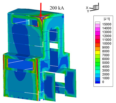
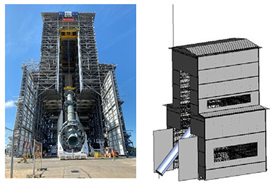 Indirect effects of lightning on systems This is an important and founding activity for the EMC theme. For example, CNES relies on ONERA's expertise to define lightning protection systems on the CSG launch sites, and to assess lightning constraints in critical operational phases such as launcher verticalization on the ZL4 launch zone illustrated opposite.
 TROPHEA testbench
Innovative experimental and modeling methods To characterize the EMC behavior of on-board electrical power systems, ONERA develops innovative methods that are implemented and validated on test benches (BRUSHLESS, TROPHEA).
Collaborative EMC simulation Over the past ten years, notably as part of European collaborative projects (FP7 HIRF-SE, H2020-EPICEA) and industrial contracts, ONERA has been developing and applying a collaborative EMC simulation methodology to model the entire problem, from the external scene, CAD and external and internal system meshing, to the equipment and its interconnection cable networks.
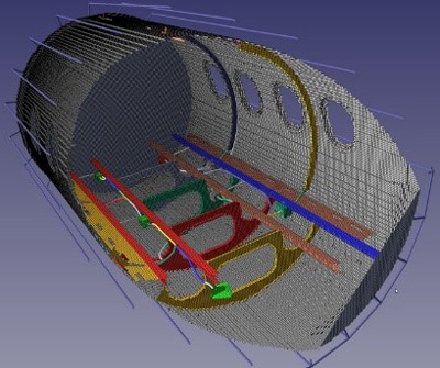
Collaborative EMC simulation on the EPICEA fuselage model (H2020):
ALICE-FDTD CAD and meshing and CRIPTE modeling of internal cable networks
Radar imaging and remote sensing
DEMR Fredéric Brigui, Jean-Philippe Ovarlez [POC name.surname@onera.fr]
- SAR image formation, particularly in difficult configurations: circular trajectories, very high spatial resolution, multistatic.
- Calibration/Validation of radar data acquired from spaceborne, airborne or UAV sensors.
- Estimation of geo-physical environmental parameters using microwave remote sensing data.
- Characterization of targets and the electromagnetic environment. Expertise and sizing of imaging radar systems.
Examples
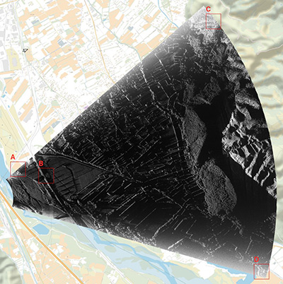
SAR imaging from signals of opportunity The SAR imaging algorithms developed for ONERA's airborne systems (SETHI, Busard) can also be used to generate SAR images from signals of opportunity emitted by external sources in bistatic configurations.
From signals emitted by the TerraSAR-X satellite, reflected by the ground and then picked up by an ONERA receiver antenna (bistatic configuration), a high-resolution X-band SAR image is generated over the Beauregard area.
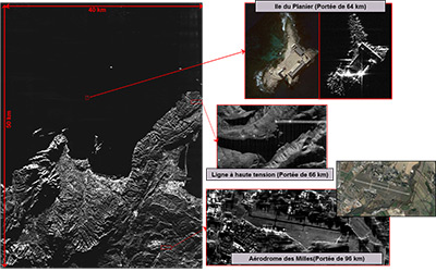
X-band SAR imaging with high spatial resolution and long range Complementarity between the SETHI airborne acquisition system and ONERA's radar imaging tools has enabled the production of an X-band SAR image with high spatial resolution (20 cm) and long range (radial swath of 50 to 100 km). This duality illustrates the effectiveness of microwave remote sensing for monitoring theaters of operation, while keeping the instrument at a safe distance.
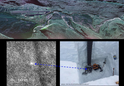
SAR imaging to detect and locate buried objects Massive multi-view processing of X-band SAR data acquired by the SETHI airborne instrument (recalibration and fusion of 432 images) enabled the detection and location of a piece of jet engine debris from flight AF66 buried under 2 m of Greenland snow.
The analysis of this part provided crucial elements for the Bureau d'enquêtes et d'analyse pour la sécurité de l'aviation civile (BEA) to identify the causes of the mid-air incident on an A380.
Propagation et radiocommunications
DEMR Vincent Fabbro, Jonathan Israël [POC name.surname@onera.fr]
Influence of the electromagnetic environment and radio propagation on telecommunication systems, radionavigation, electronic warfare and radar.
- Modeling (physical, statistical): propagation, clutter, medium
- Characterization of the propagation environment: ionosphere, troposphere, terrestrial and maritime environments
- Measurements (specific equipment)
- Processing techniques
- Simulation of radio communication systems
Examples
ONERA carries out measurements of tropospheric propagation effects for CNES, ESA and Eumetsat, as well as for its own needs. Illustration of the results of the measurement campaign carried out at the French Guiana Space Center, completed with the collection of three years of data with exceptional availability given the remoteness of the site
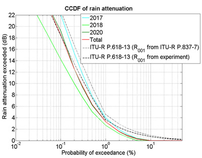 Plot showing the probability (as a percentage of an average year, represented on the x-axis) of exceeding rain attenuation in dB (on the y-axis), derived from the experimental campaign conducted at 20 GHz by CNES and ONERA at the Guiana Space Center in Kourou in 2017, 2018 and 2020, and predicted by the International Telecommunication Union rain attenuation model (Rec. ITU-R P.618-13).
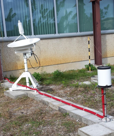 CNES receiving station for the Amazonas 20 GHz beacon
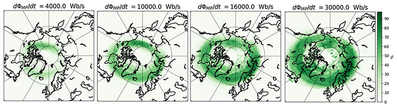
To predict the state of the propagation channel in the Arctic, ONERA is developing a statistical model for the occurrence of ionospheric scintillation affecting GNSS signals and telecommunications links, in collaboration with the NMA (Norwegian Mapping Authority). This model, called HAPEE (High Latitude Ionospheric Disturbances Positioning Error Estimator), predicts the occurrence of scintillation within the next hour (see illustration), using as input solar wind measurements taken at the L1 Lagrange point by sensors onboard the ACE satellite.
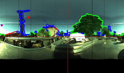 Example of semantic image segmentation for different environments and acquisition conditions. Vegetation is indicated in green, buildings in red, points in blue and the sky retains its initial radiometry (rest of image). The line of sight is indicated by a magenta disc.
ONERA is also continuing the joint exploitation of RF and video data to statistically characterize the mobile propagation channel according to the environment encountered (presence of vegetation, buildings, pylons or an open environment). Image data acquired simultaneously with RF data can be used automatically by deep learning algorithms to determine the presence and type of obstacle in the line of sight (see illustration).
Simulation of the electromagnetic scene
DEMR Vincent Gobin, Jérôme Simon. [POC name.surname@onera.fr]
Electromagnetic modeling and simulation
- Modeling focuses on the representation of physical phenomena and their validation.
- Simulation concerns the exploitation of models, in computer environments such as platforms or simulators, working on databases.
Numerical resolution of Maxwell's equations
- “Exact" methods: time, frequency, domain decomposition; compression algorithms
- Asymptotic methods: geometric optics, physical optics, ray methods
- Computer optimization (HPC, GPU)
- Modeling and calculation of radar signatures, antennas, EMC.
Software platforms and simulators for complex scenes
- Complex scenes involving targets and radars
- Complex systems such as vehicles or installations
- Radar and electromagnetic sensor models
- Geo-referenced clutter models
Contribution to the "electromagnetic environment referent" mission entrusted by DGA (French Government Defense procurement and technology agency) to ONERA.
Examples
![Applications : [haut gauche] détection d’armes sur personnes en mouvement [haut droite] diagramme de SER multi-statique [bas gauche] propagation d’une onde à travers un jet de propulseur [bas droite] rayonnement d’un réseau de 200 antennes](/sites/default/files/recherche/phy/ssem-all-400.jpg) Applications: [top left] detection of weapons on moving people [top right] multi-static SER diagram [bottom left] wave propagation through a thruster jet [bottom right] radiation from an array of 200 antennas.
Applications: [top left] detection of weapons on moving people [top right] multi-static SER diagram [bottom left] wave propagation through a thruster jet [bottom right] radiation from an array of 200 antennas.Codes for solving Maxwell's equations in frequency and time
They use ONERA and GENCI HPC architectures. Maxwell3D, FACTOPO_FEM-FETI, MaxwellTD and ALICE are used to carry out complex studies.
They are also regularly confronted with the European state of the art through various workshops (EM ISAE and EM EDA).
 Visible images and their synthetic SAR counterparts
Simulation of complex scenes - EMPRISE is the reference system developed by ONERA for electromagnetic simulation of complex scenes for the DGA, industry and academia. This work gives concrete expression to ONERA's role as "environmental referent" for the DGA.
ONERA relies on subcontractors for IT development and the creation of virtual terrain databases (SCALIAN-DS, OKTAL-SE and FWD).
 Preview of a PATMAR simulation (radar rendering)
PATMAR (Simulation de PATtrouille MARitimes) and STIMUSAR (STIMUlation SAR) are the first two EMPRISE applications.
The distribution of the first versions of the software tools to the MBDA and Thales manufacturers is the culmination of the efforts of the entire project team. The EMPRISE market is designed to support the use of the reference system by manufacturers over the period 2021-2025.
Systems and technologies for radar and electronic warfare
DEMR Philippe Brouard, Jean-François Nouvel [POC name.surname@onera.fr]
Areas of excellence
- Radar and multifunction systems
- Microwave system design
- High-rate sampling
- On-board digital processing
- Transmit/Receive technologies
- Compact short-range radar and sensors
Scientific and technical goals
- System studies and development of demonstrators for radar and electronic warfare (EW)
- Design and production of measurement systems for characterizing targets, scenes and radar environments.
Core competencies
- System expertise based on knowledge of radar target and scene physics, covering sensor technologies, integration, signal processing and metrology tools. Expertise based on a fleet of test facilities unique in Europe.
Examples
Combining open architectures and increasing part of digital modules, systems developed by ONERA enable us to experiment new modes of observation, such as multistatic imaging.
 Bistatic SAR configuration using the TerraSAR-X satellite as a radar transmitter and the BUSARD receiver operating in X-band.
 ISAR image obtained on an airliner with the HYCAM radar as transmitter and the MEDYCIS station as receiver.
The development of ever more powerful and compact technologies has also made it possible to design on-board payloads for radar and electronic warfare applications. ONERA is developing payloads for nanosatellites, for example, to provide HF sounding of the ionosphere for the Nostradamus trans-horizon radar, or for UAVs for observation missions and see-and-avoid functions.
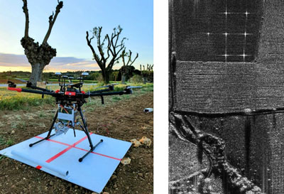
Mounting an X-band radar sensor on a commercial drone (DJI M600, left) and an example of a radar image recorded with this sensor (right).
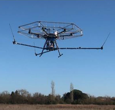 Installation of a radar sensor dedicated to the "see and avoid" function during flight tests. Electromagnetic shielding was tested around the drone's propellers.
To meet and anticipate future threats, ONERA studies, develops and evolves large-scale radar demonstrators for advanced warning functions.
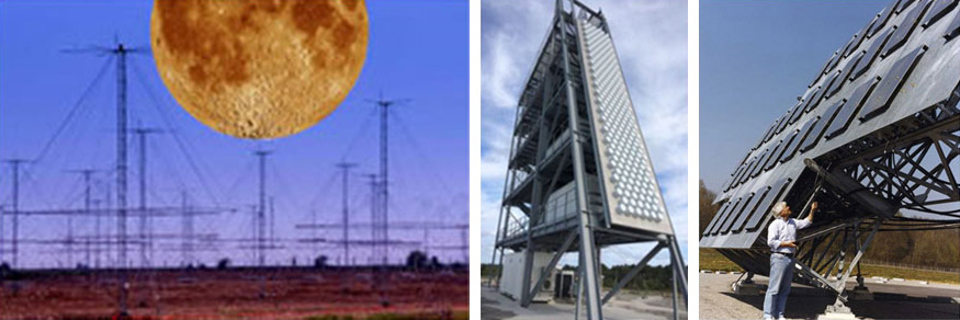
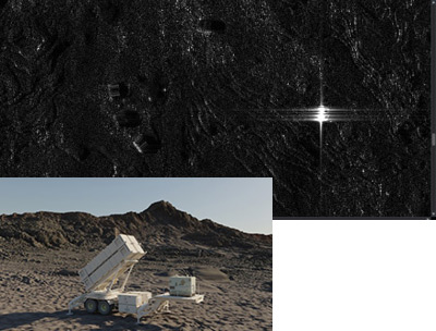
Nostradamus over-the-horizon radar (left) and the Very Long Range Radar Demonstrator (DR-TLP, center), or for space surveillance (GRAVE, right).
Signal processing for radar and electronic warfare
DEMR Olivier Rabaste, Thierry Deloues [POC name.surname@onera.fr]
- Detection and estimation
- Classification, identification, recognition, learning
- Filtering (matched and mismatched filter, interference filtering) and radar tracking (Kalman and particle filter)
- Antenna processing
- Direction finding
- Waveforms
Exemples
 Time-frequency representation of a sequence of simulated bat signals, modeled from real signals
ONERA studies many innovative waveforms for radar applications, and the associated processing, in order to respond to new problems and emerging applications: MIMO (Multiple Input Multiple Output) radar, multi-static radar, joint radar-communication systems... Studies range from solving complex optimization problems to studying biological signals, such as those from bats!
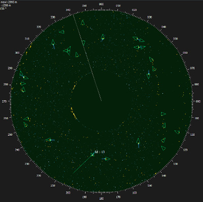
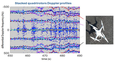 Doppler signatures of a quadrotor drone. These figures were obtained in the context of drone control using passive radar, with the recording and processing of experimental measurements.
ONERA is an expert in the recording and processing of passive signals. For many years, processing algorithms developed at ONERA/DEMR, applied to DVB-T digital television signals recorded in this way, have demonstrated good bistatic detection and localization capabilities on fixed- and rotary-wing micro and mini-UAVs. Classification algorithms were also developed to classify UAVs on the basis of their Doppler signature.
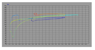 GPS position (ground truth)
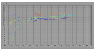 Localized dots provided by pass processing
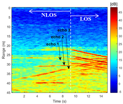
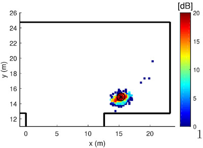
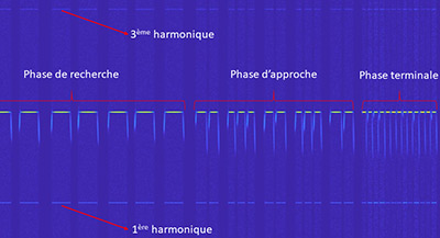
ONERA is developing numerous processing tools to detect and locate targets in complex environments. Specific detection tests have been proposed to deal with the presence of complex, strong clutter generated by ground echoes (buildings, trees, sea, etc.), as well as techniques for exploiting knowledge of the environment to improve radar system performance. Applications such as "around-the-corner" radar are also being studied: in this case, the aim is to detect and locate targets that are not in the radar's direct line-of-sight.
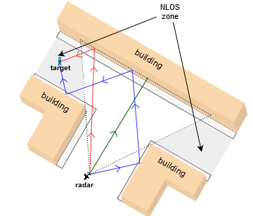
Around-the-corner radar: detection and localization of hidden targets in an urban environment (top). Actual measurements (center) and localization by particle filtering (bottom)